


Basics
- Length:
- 178.8 miles (287 km)
- Time:
- 5 to 6 hours to visit the entire Byway.
- Fees:
- There are no fees to drive the Byway.
Description
In 1912, the idea of roads as fast transportation did not exist in America. Dirt roads spread out from settlements at random, some not leading anywhere, and travelers found it easier to take the train to the next town over. Dust blew over the roads when the weather was dry; when the weather was wet, vehicles bogged down and couldn't move. But all that would change when Carl Fisher conceived and promoted the first paved transcontinental highway in the United States. To promote funding, he named it after a great American hero, and the project became the Lincoln Highway.
The Lincoln Highway in Illinois follows the original route of that ambitious project, with several historic sites along the road. Fisher paved sections of road called "seedling miles," designed to entice contributors by showing the superiority of paved roads over dirt. These original sections remain a part of the Byway, along with several carefully preserved original navigation markers, allowing visitors to get a sense of the original journey.
Illinois history is connected in strange ways, and several sites along the Byway link local and national events. A great statue of Black Hawk towers over the river near the city of Oregon, commemorating the original inhabitants of the land. Another statue in Dixon shows Abraham Lincoln in uniform, commemorating his involvement in the Black Hawk War. Dixon would later be the boyhood home of President Ronald Reagan, and his statue is featured in front of the site.
The Lincoln Highway connected America, and today, Lincoln Highway in Illinois connects visitors to the fascinating national, natural, and local history of Illinois.
Tourism Resources
Helpful Links
Tourism Resources
Points of Interest
Points of Interest Along The Way
1918 Standard Oil Filling Station (IL)
This station was the first gasoline filling station in Rochelle and the first filling station on the Lincoln Highway in Ogle County. Restoration of the building includes travel memorabilia, vintage artifacts, 1918 pumps and more. It serves as the Visitor Center for the City of Rochelle.
1928 Concrete Marker (IL)
About 3,000 concrete markers were planted all across the country by the Boy Scouts on September 1, 1928; 253 markers were placed in Illinois. West of Ashton, four concrete markers are still on or near the roadway. Less than 40 markers are known to still be in Illinois, with very few located near the original roadway.
Abandoned Roadway-Franklin Grove (IL)
At this site is another abandoned segment of the original Lincoln Highway alignment. This segment leads up to where a bridge once spanned the Franklin Creek. Travelers will find segments all along the Lincoln Highway that have been forgotten and fallen into disrepair. At the same time, these segments give travelers a good idea of what the road may have originally looked like.
Arche Fountain (IL)
This memorial fountain was erected in 1916 by the Conservation Committee of the Arche Club of Chicago as a place of rest for cross-country travelers on the Lincoln Highway.
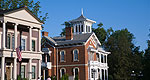
Aurora (IL)
There are lots of things to do and see in Aurora. This town is the 3rd largest in Illinois and an excellent stop while driving the Lincoln Highway. Settled in the early 1800's, the town of Aurora features stories and museums for curious travelers. Make sure you take an opportunity to enjoy the history of this city on the Lincoln Highway.
Aurora features architectural tours that showcase the unique ways that the buildings of this city have been structured. There are 9 historic districts throughout the city with various forms of ornate and unusual architecture. La Salle Street is one of these historic districts. This street is on the Register of Historic Places and was called Aurora's Auto Row. It is significant for its Victorian era, 20th Century commercial-style, and fraternal lodge buildings. It was once the automobile commercial center of Aurora.
Be sure to catch a glimpse of another unique architectural aspect of the Lincoln Highway. Aurora's water sculpture, known as the "Swimming Stones," was created by Christian Tobin for the city's Downtown Art and Science Walk series.
Batavia (IL)
Settled in the 1830s, Batavia has continually grown andflourished throughout the decades. It is a city of fine architecture and history, yet it takes advantage of modern growth and development of today. Batavia's first industry was that of producing windmills. For a time, it was known as the "Windmill City." The limestone quarries of Batavia were utilized in rebuilding the city of Chicago after the Great Chicago Fire. Enjoy touring the city of Batavia, or exploring some of the recreational opportunities thereabouts.
While you're here don't miss the historical Bellevue Place. Bellevue was once a private academy called Batavia Institute. The building was later turned into an upscale sanitarium. During this time, Mary Todd Lincoln stayed here under a court order instigated by her son, Robert. The building is not open to the public but you can see the furnishing Mrs. Lincoln used while she was there, at the Depot Museum in Batavia.
Batavia River Walk (IL)
Enjoy this 3.2-acre park with boardwalks and a wildflower garden. Visitors will also find the Batavia Depot Museum where railroad and war history can be found alongside Batavia-related exhibits.
Bird Haven Greenhouse and Conservatory (IL)
The Bird Haven Greenhouse and Conservatory was constructed in the early 1900's. The Italian Renaissance-style facility features floral shows with seasonal motifs. The venue hosts a variety of programs and special events, including weddings.
Black Hawk Statue (IL)
Directions
In Rochelle, turn north on State Road 251. Continue to the junction of State Route 64. Turn left on State Route 64, and continue through Kings into Oregon. In Oregon, turn right on N. River Road, and follow it into Lowden Miller State Forest. The statue overlooks the bank of the Rock River.
Black Hawk Statue (IL)
This statue was designed by artist Lorado Taft as a memorial toBlack Hawk and his people who once lived in the midwest. Thelighted figure is 48 feet tall and stands above the beautiful RockRiver at Lowden State Park.
Directions
In Rochelle, turn north on State Road 251. Continue to the junction of State Route 64. Turn left on State Route 64, and continue through Kings into Oregon. In Oregon, turn right on N. River Road, and follow it into Lowden Miller State Forest. The statue overlooks the bank of the Rock River.
Blackberry Farm's Pioneer Village (IL)
Blackberry Farm's Pioneer Village is a living history museum situated on 54 scenic acres with a lake, ponds and a meandering stream. The grounds contain an arboretum with over 200 varieties of trees and many gardens, floral displays and historic agricultural gardens.
In the Village there are five large museum collections, including the Carriage House, the Farm Museum, the Early Streets Museum and the Huntoon House. These contain an outstanding collection of late 19th century artifacts used in every facet of life. The Carriage collection houses 40 carriages, sleighs and commercial vehicles. The Farm collection has many particularly rare implements dating from the mid-1800s to 1910. The Streets Museum houses 11 late Victorian era exhibit stores including a music shop, a pharmacy, a general store, a photography shop and a toy store.
Many period craft demonstrations bring the Village to life. They are blacksmithing, spinning, weaving, sewing and pottery, as well as a one room schoolhouse, an Aurora home from the 1840s and a farm cabin. In each area demonstrators depict activities and life of the bygone era.
Children and their parents will enjoy a ride on the train to visit the cabin, where they can take an old hay wagon ride along Blackberry Creek. Returning to the Village they can ride the carousel or the ponies. (weight limit on ponies is 70 lbs.)

